Arctic Oscillation brings record low January Ice extent
- Details
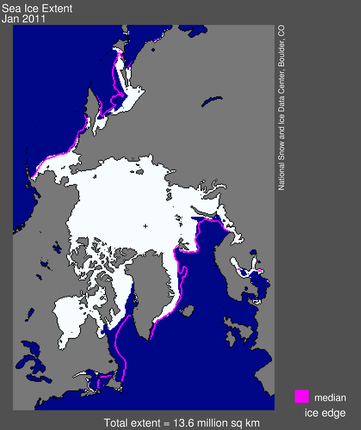
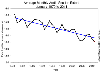
 Arctic sea ice extent for January 2011 was the lowest in the satellite record for that month due to slow regional ice growth compared to past years. This is reported at the National Snow and Ice Data Center. For example Hudson Bay did not completely freeze up until mid-January, about a month later than normal according to Canadian Ice Service analyses. Arctic sea ice extent averaged over January 2011 was 13.55 million square kilometers (5.23 million square miles). This was the lowest January ice extent recorded since satellite records began in 1979. It was 50,000 square kilometers (19,300 square miles) below the record low of 13.60 million square kilometers (5.25 million square miles), set in 2006, and 1.27 million square kilometers (490,000 square miles) below the 1979 to 2000 average.
 Air temperatures over much of the Arctic were 2 to 6 degrees Celsius (4 to 11 degrees Fahrenheit) above normal in January. Over the eastern Canadian Arctic Archipelago, Baffin Bay/Davis Strait and Labrador Sea, temperatures were at least 6 degrees Celsius (11 degrees Fahrenheit) higher than average. Temperatures were near average over the western Canadian Arctic Archipelago and Scandinavia.
Warm conditions in the Arctic and cold conditions in northern Europe and the U.S. are linked to the strong negative mode of the Arctic oscillation. Cold air is denser than warmer air, so it sits closer to the surface. Around the North Pole, this dense cold air causes a circular wind pattern called the polar vortex , which helps keep cold air trapped near the poles. When sea ice has not formed during autumn and winter, heat from the ocean escapes and warms the atmosphere. This may weaken the polar vortex and allow air to spill out of the Arctic and into mid-latitude regions in some years, bringing potentially cold winter weather to lower latitudes.
 Some scientists have speculated that more frequent episodes of a negative Arctic Oscillation, and the stormy winters that result, are linked to the loss of sea ice in the Arctic. Dr. James Overland of NOAA Pacific Marine Environmental Laboratory (PMEL) recently noted a link between low sea ice and a weak polar vortex in 2005, 2008, and the past two winters, all years with very low September sea ice extent. Earlier work by Jennifer Francis of Rutgers University and colleagues also suggested a relationship between autumn sea ice levels and mid-latitude winter conditions. Judah Cohen, at Atmospheric and Environmental Research, Inc., and his colleagues propose another idea—a potential relationship between early snowfall in northern Siberia, a negative phase of the Arctic Oscillation, and more extreme winters elsewhere in the Northern Hemisphere. More research on these ideas may shed light on the connections and have the potential to improve seasonal weather forecasting.
The Arctic Oscillation
The Arctic Oscillation refers to opposing atmospheric pressure patterns in northern middle and high latitudes.
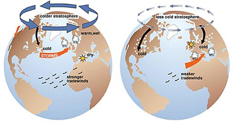
 The oscillation exhibits a "negative phase" with relatively high pressure over the polar region and low pressure at midlatitudes (about 45 degrees North), and a "positive phase" in which the pattern is reversed. In the positive phase, higher pressure at midlatitudes drives ocean storms farther north, and changes in the circulation pattern bring wetter weather to Alaska, Scotland and Scandinavia, as well as drier conditions to the western United States and the Mediterranean. In the positive phase, frigid winter air does not extend as far into the middle of North America as it would during the negative phase of the oscillation. This keeps much of the United States east of the Rocky Mountains warmer than normal, but leaves Greenland and Newfoundland colder than usual. Weather patterns in the negative phase are in general "opposite" to those of the positive phase, as illustrated below.
Over most of the past century, the Arctic Oscillation alternated between its positive and negative phases. Starting in the 1970s, however, the oscillation has tended to stay in the positive phase, causing lower than normal arctic air pressure and higher than normal temperatures in much of the United States and northern Eurasia.
Source:NSIDC
