
News
Bering Strait Shipping in 2024: Trends, Challenges, and an Unusual Ice Barrier
The The Marine Exchange of Alaska (MXAK) has released its latest report, "Bering Strait and Transits," providing an in-depth analysis of maritime traffic in the Bering Strait during 2024. As Arctic sea routes continue to draw global interest due to climate change and shifting economic opportunities, this report offers valuable insights into vessel movements, trends, and the impact of environmental conditions on shipping in the region.
Since 2009, MXAK has been monitoring vessel traffic in the Bering Strait through Automatic Identification System (AIS) transmissions. This long-term dataset allows for comparisons over time, highlighting key developments in Arctic shipping patterns. The 2024 report examines vessel types, transit frequencies, and regulatory impacts, painting a comprehensive picture of maritime activity in this critical gateway between the Pacific and Arctic Oceans.
This report is particularly significant in the context of unusual sea ice conditions observed in September 2024. Unlike in previous years, sea ice was densely packed from the mainland to Wrangel Island, presenting an unexpected barrier to navigation. This development raises important questions about ice variability and its implications for Arctic shipping routes. The yearly fluctuations in sea ice coverage, as illustrated in the report, highlight the necessity of high-quality monitoring and real-time navigational support. These tools are crucial not only for environmental protection but also for vessel safety. Strengthening monitoring capabilities and improving data interpretation through international collaboration will be essential for the successful and sustainable utilization of Arctic sea routes. A coordinated approach focusing on environmental, social, and economic aspects in a global context, is key to viable and increased Arctic shipping.
The report "Bering Strait and Transits"
Introduction
The Arctic is undergoing rapid environmental changes that are forecasted to significantly alter maritime traffic. Baseline data on current traffic patterns and area usage are useful in anticipating the future needs of the maritime community operating in the Arctic.
![]() In 2009, the Marine Exchange of Alaska (MXAK) began recording vessel traffic through the Bering Strait and Arctic region by monitoring the AIS (Automatic Identification System) transmissions of vessels equipped with this technology. International maritime treaties require all vessels over 300 gross tons, and all passenger ships engaged in international trade to be equipped with AIS. In 2016 U.S. Coast Guard regulations expanded the AIS carriage requirement to all commercial vessels over 65’ in length, including fishing vessels and towing vessels over 26 feet in length. As the cost of AIS equipment decreased over time many vessels not required to carry have installed AIS transceivers. As a result, more vessels are now transmitting information on AIS than in 2009 when MXAK first started recording maritime activity in the Bering Strait.
In 2009, the Marine Exchange of Alaska (MXAK) began recording vessel traffic through the Bering Strait and Arctic region by monitoring the AIS (Automatic Identification System) transmissions of vessels equipped with this technology. International maritime treaties require all vessels over 300 gross tons, and all passenger ships engaged in international trade to be equipped with AIS. In 2016 U.S. Coast Guard regulations expanded the AIS carriage requirement to all commercial vessels over 65’ in length, including fishing vessels and towing vessels over 26 feet in length. As the cost of AIS equipment decreased over time many vessels not required to carry have installed AIS transceivers. As a result, more vessels are now transmitting information on AIS than in 2009 when MXAK first started recording maritime activity in the Bering Strait.
The report provides a summary of AIS equipped vessel transits in 2024 and makes comparisons to data gathered over the past decade.
The Bering Strait
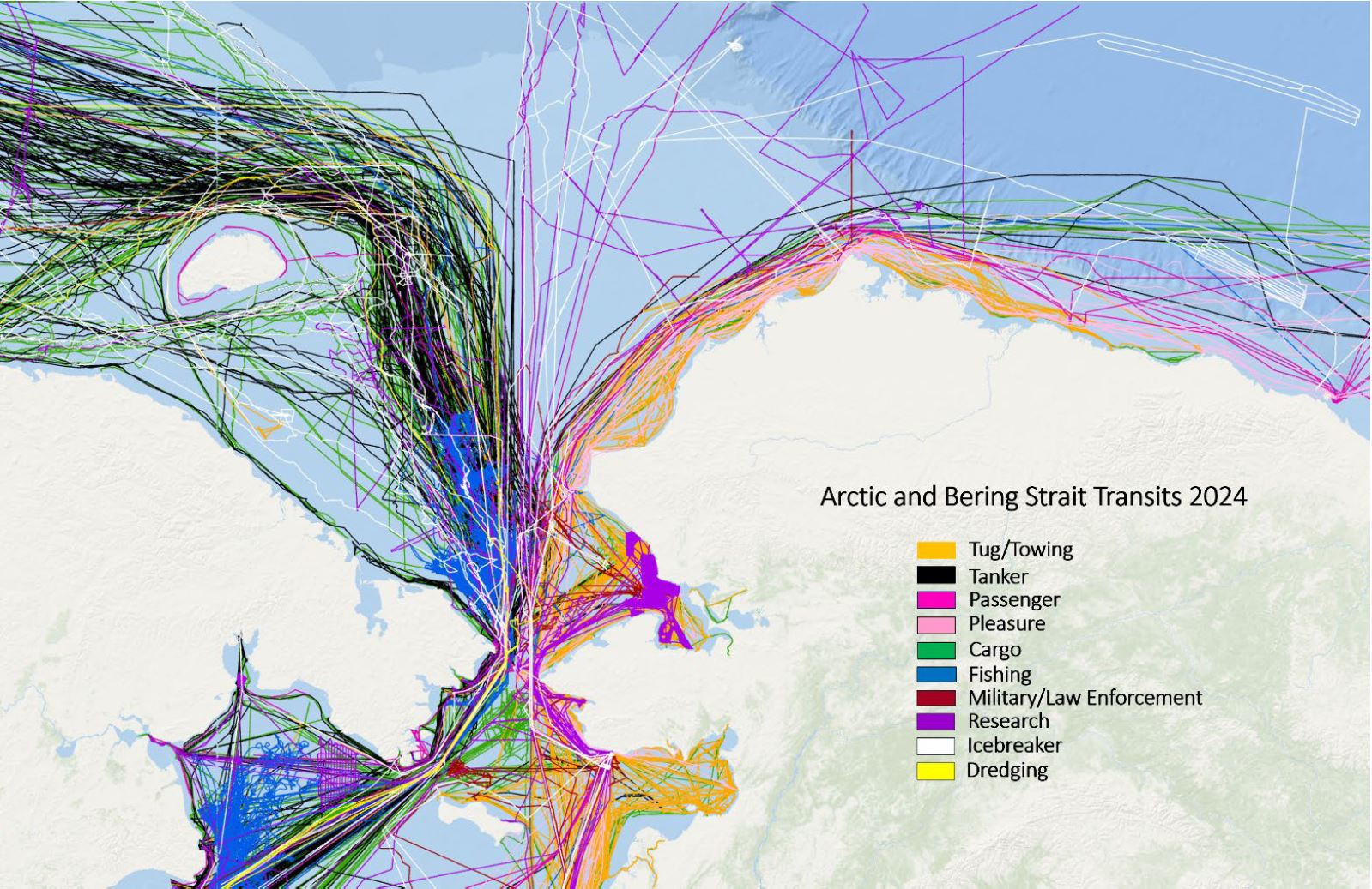
![]() In Table 1, northbound and southbound vessel transits were recorded as they passed over a virtual line between the closest points of mainland in the strait. While vessels could report multiple transits over the passageline throughout the year, they were limited to one northbound and one southbound transit per day in analysis.
In Table 1, northbound and southbound vessel transits were recorded as they passed over a virtual line between the closest points of mainland in the strait. While vessels could report multiple transits over the passageline throughout the year, they were limited to one northbound and one southbound transit per day in analysis.
Figures 1 (above) and 2 (to the side) were built by using the MMSI’s of vessels that posted a transit across the Bering Strait passageline at least once during the year. Vessels that stayed north or south of the Strait for the entire year are not displayed in these figures.
In Figure 3 (vessel types) vessels were categorized by self-reported AIS types. Ships that identified as “Other” or otherwise not self-identified were categorized using the Lloyd’s List Seasearcher. Fishing vessel increases in 2017 and 2018 may be due to U.S. Coast Guard’s expanded AIS carriage requirements; but the increased number of fishing vessels in 2022 is notable.
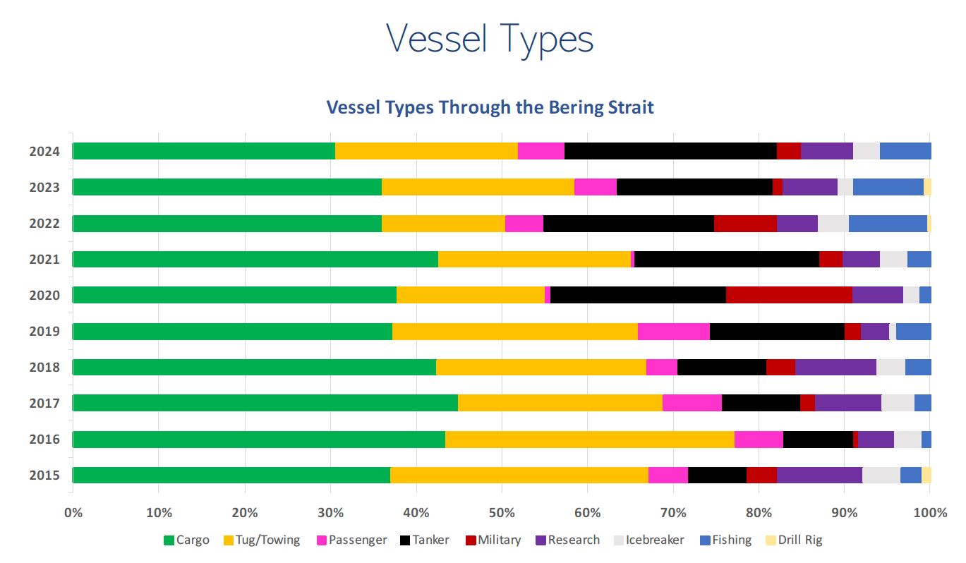
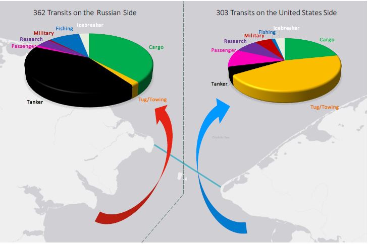
Figure 4 (to the left) breaks down vessel types by side of the Bering Strait they transit. While ships on either side are analogous in most categories, cargo vessels are not. Cargo vessels on the U.S. side are typically regional landing craft, averaging 28 meters in length. On the Russian side the average length of a cargo vessel is 160 meters.
Season Lengths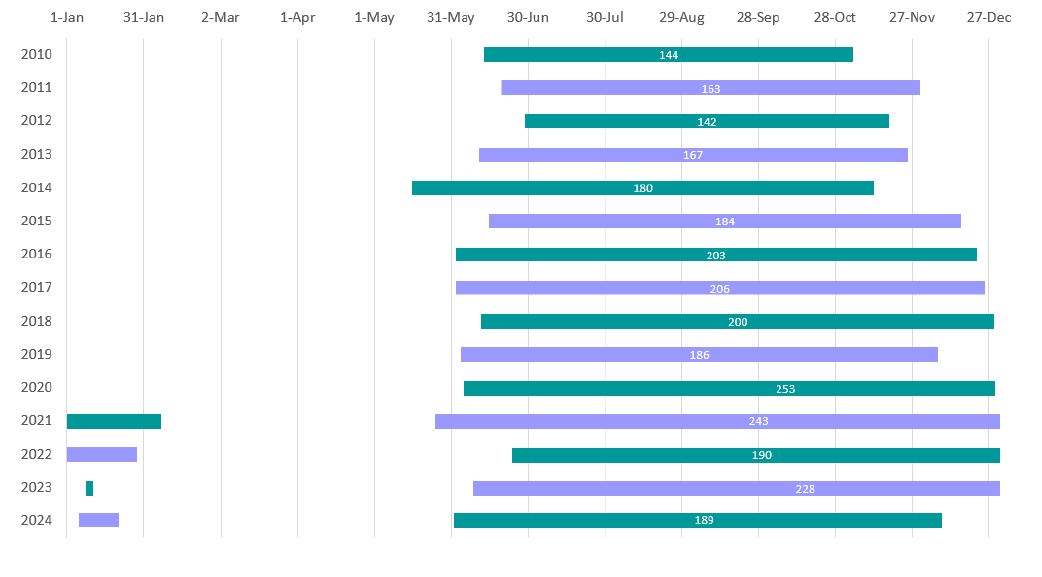
Figure 9 (to the right) looks at the first and last dates that vessels crossed (either north or south) through the Bering Strait. In the winter of 2020 transits continued past the end of the calendar year into the next January and February. That pattern repeated for the 2021 and 2022 seasons. No transits through the Bering Strait have been recorded in the first months of 2025.
Source: Marine Exchange of Alaska (MXAK)

Concluding Remarks
The findings of the "Bering Strait and Transits" report underscore the dynamic nature of Arctic maritime activity and the growing importance of detailed, real-time monitoring. The packed ice in September 2024 serves as a reminder that, despite overall trends of diminishing Arctic ice, localized and seasonal variations can still present significant challenges to navigation.
As stakeholders, from policymakers to shipping companies, assess the evolving conditions of the Arctic, reports like this remain essential in guiding decision-making. The ability to anticipate shifts in transit patterns, regulatory requirements, and environmental constraints will be crucial for ensuring safe and sustainable maritime operations in the North while minimizing the environmental impact.
Related news and articles:
The tags below provide an opportunity to view previously posted related news within the selected category