
News
Increased chance of eruption in Iceland the next few days - again!
Increased risk level in updated risk assessment
Updated news from the Icelandic Met Office February 26 at 16:10

The amount of magma under Svartsengi, by the town of Grindavik, approaches the same level as on the eve of previous eruptions. An eruption could start with very short notice, even less than 30 minutes. The increased danger level is reported in the updated danger assessment due to an impending eruption. It is most likely that an eruption will occur in the area between Stóra-Skógfell and Hagafell.
The risk assessment does not take into account weather conditions or other factors that can affect the risk of being within the danger zones. It is possible that a magma flow will start without an eruption.
 Model calculations show that around 7.6 million cubic meters of magma have now accumulated under Svartsengi. If compared with the eve of previous volcanic eruptions in the Sundhnúks crater series, the probability of an eruption increases when the volume has reached 8 – 13 million cubic meters. If magma accumulation continues in the same way, the lower limit will be reached tomorrow.
Earthquake activity has increased slightly over the weekend and the highest activity has been just east of Sýlingarfell. The location of the seismic activity is in the areas where it is believed that the eastern end of the magma intrusion under Svartsengi lies. This is comparable to the seismic activity seen in the days before previous eruptions.
Updated hazard assessment
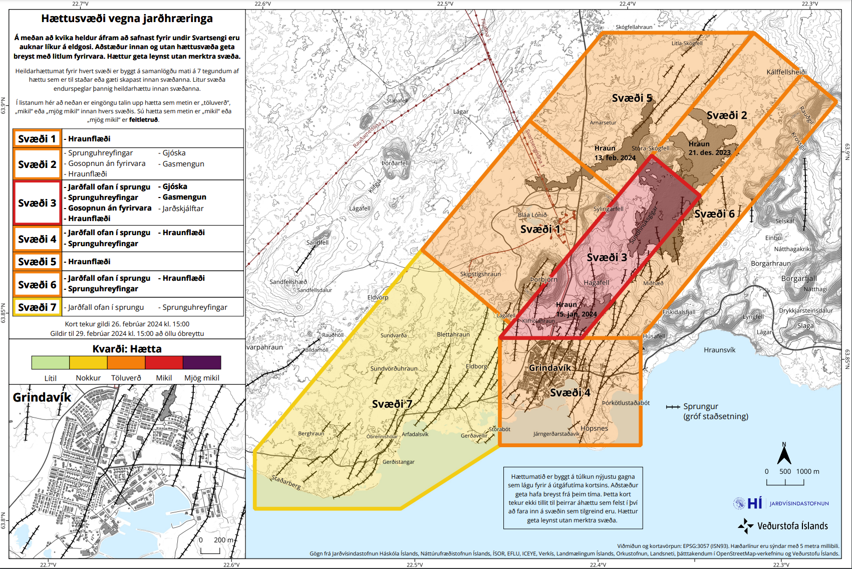 In light of the above, the Icelandic Meteorological Office has updated the risk assessment for the upheaval areas. The increased probability of a volcanic eruption and thus the associated volcanic risk affects the risk assessment. The danger level has been increased in several areas. Zone 3 – Sundhnjúka crater series has been upgraded to high risk (red) due to eruptions without warning. Zone 1 - Svartsengi has risen to considerable (orange) due to possible lava flow. Zone 4 - Grindavík remains orange, but there is an increased risk within that zone due to a possible lava flow.
No significant land changes are visible within Grindavík on GPS or satellite data. New cracks are likely to appear on the surface when snow melts or when soil moves due to rainfall and falls into cracks that have already formed but are currently unnoticed.
Likely scenarios
It is the opinion of scientists that if there is an eruption, it is most likely that the magma will move from Svartsengi to the Sundhnúksgíga series and that an eruption will occur in the area between Stóra-Skógfell and Hagafell. Signs that magma is making its way up to the surface come in sudden, localized, and intense micro-seismic activity. In previous recent eruptions in the area, an eruption could start with little notice, less than 30 minutes, depending on where on the Sundhnúks crater series the magma emerges.
Source: MET Office Iceland
Related news:
Another eruption started on the Reykjanes Peninsula
Volcanic eruption started close to Grindavík, Iceland
Is Another Volcanic Eruption Looming on Reykjanes Peninsula, Iceland?
The tags below provide an opportunity to view previously posted related news within the selected category